Property Record
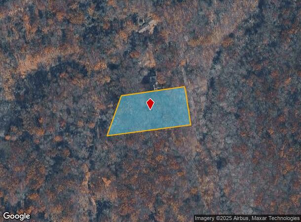
Black River Rd, Washington, NJ 07882

This Property Is For Sale
NEARBY LISTINGS FOR SALE OR LEASE
-
-
View all Washington listings for sale on LoopNet.com
Property Detail
Black River Rd
Newark, NJ
Morris
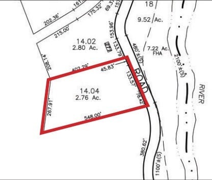
38-00063-0000-00014-04
New Jersey
Vacantlandnec
14.4
2024
2.76 AC
2025
Western Morris
032000
Northern New Jersey
DEMOGRAPHICS near Black River Rd
1 mile
3 mile
5 mile
2024 Total Population
236
4,059
17,179
2029 Population
230
3,971
16,913
Pop Growth 2024-2029
(2.54%)
(2.17%)
(1.55%)
Average Age
46
45
44
2024 Total Households
85
1,440
6,064
HH Growth 2024-2029
(3.53%)
(2.36%)
(1.73%)
Median Household Inc
$170,000
$178,603
$160,577
Avg Household Size
2.70
2.70
2.80
2024 Avg HH Vehicles
3.00
3.00
2.00
Median Home Value
$711,956
$722,590
$717,997
Median Year Built
1975
1975
1974
Nearby Places
Map Layers
Map Styles
 Street
 Aerial
Transit
 Traffic
 Biking
Places
Listings with unknown addresses are not visible on the map
- Restaurants
- Banks
- Shops
- Fitness
- Groceries
PUBLIC TRANSPORTATION
COMMUTER RAIL
Gladstone (Morris & Essex Gladstone Branch - NJ Transit Commuter Rail (NJ Transit))
Drive
Walk
Distance
Gladstone (Morris & Essex Gladstone Branch - NJ Transit Commuter Rail (NJ Transit))
10 min
4.5 mi
Peapack (Morris & Essex Gladstone Branch - NJ Transit Commuter Rail (NJ Transit))
Drive
Walk
Distance
Peapack (Morris & Essex Gladstone Branch - NJ Transit Commuter Rail (NJ Transit))
12 min
5.6 mi
AIRPORT
Newark Liberty International
Drive
Walk
Distance
Newark Liberty International
52 min
39.3 mi
Freight Ports
New York Container Terminal
Drive
Walk
Distance
New York Container Terminal
62 min
46.4 mi
Nearby Properties
Address
Land Use
TOTAL SIZE
Lot Size
Zoning
Address
Land Use
TOTAL SIZE
Lot Size
Zoning
32,578 SF
298.72 AC
R10
Address
Land Use
TOTAL SIZE
Lot Size
Zoning
708.10 AC
R-5
Address
Land Use
TOTAL SIZE
Lot Size
Zoning
610.04 AC
R-5
Address
Land Use
TOTAL SIZE
Lot Size
Zoning
23.54 AC
HL
Address
Land Use
TOTAL SIZE
Lot Size
Zoning
149.99 AC
R10
Address
Land Use
TOTAL SIZE
Lot Size
Zoning
258.33 AC
R-5
Address
Land Use
TOTAL SIZE
Lot Size
Zoning
32.60 AC
R10
Address
Land Use
TOTAL SIZE
Lot Size
Zoning
Address
Land Use
TOTAL SIZE
Lot Size
Zoning
213.55 AC
R-5
Address
Land Use
TOTAL SIZE
Lot Size
Zoning
11,270 SF
6.30 AC
R10
Address
Land Use
TOTAL SIZE
Lot Size
Zoning
17,652 SF
2 AC
R10
Address
Land Use
TOTAL SIZE
Lot Size
Zoning
9,949 SF
3.50 AC
R10
Address
Land Use
TOTAL SIZE
Lot Size
Zoning
1,760 SF
179.01 AC
R-5
Address
Land Use
TOTAL SIZE
Lot Size
Zoning
9,610 SF
10.33 AC
R10
Address
Land Use
TOTAL SIZE
Lot Size
Zoning
9,240 SF
4 AC
R10
Address
Land Use
TOTAL SIZE
Lot Size
Zoning
12,352 SF
5.37 AC
R10
Address
Land Use
TOTAL SIZE
Lot Size
Zoning
3,988 SF
13.99 AC
R10
Address
Land Use
TOTAL SIZE
Lot Size
Zoning
8,055 SF
4.17 AC
R-5
Address
Land Use
TOTAL SIZE
Lot Size
Zoning
6,509 SF
3 AC
R10
Address
Land Use
TOTAL SIZE
Lot Size
Zoning
7,200 SF
2 AC
R10
Address
Land Use
TOTAL SIZE
Lot Size
Zoning
7,872 SF
2 AC
R10
Address
Land Use
TOTAL SIZE
Lot Size
Zoning
7,059 SF
2.58 AC
R10
Address
Land Use
TOTAL SIZE
Lot Size
Zoning
5,808 SF
3 AC
R10
Address
Land Use
TOTAL SIZE
Lot Size
Zoning
8,487 SF
2 AC
R10
Address
Land Use
TOTAL SIZE
Lot Size
Zoning
5,846 SF
10 AC
HL
Address
Land Use
TOTAL SIZE
Lot Size
Zoning
12,973 SF
1 AC
R10
Address
Land Use
TOTAL SIZE
Lot Size
Zoning
10,021 SF
9.55 AC
R10
Address
Land Use
TOTAL SIZE
Lot Size
Zoning
10,376 SF
3 AC
R10
Address
Land Use
TOTAL SIZE
Lot Size
Zoning
9,238 SF
3 AC
R10
Address
Land Use
TOTAL SIZE
Lot Size
Zoning
7,326 SF
11.91 AC
R-5
The World's #1 Commercial Real Estate Marketplace
Connect with us
© 2026 CoStar Group
The information above has been obtained from sources believed reliable. While we do not doubt its accuracy we have not verified it and make no guarantee, warranty or representation about it. It is your responsibility to independently confirm its accuracy and completeness. Any projections, opinions, assumptions, or estimates used are for example only and do not represent the current or future performance of the property. The value of this transaction to you depends on tax and other factors which should be evaluated by your tax, financial, and legal advisors. You and your advisors should conduct a careful, independent investigation of the property to determine to your satisfaction the suitability of the property for your needs.